Tatshenshini River Blowout
Tatshenshini River Blowout
Submitted by Bruce Ripley
You ever wonder about how rivers change and how long it takes for that to happen? How long has it taken to carve the Grand Canyon? Hells Canyon? Owyhee? Rogue? And the list goes on. Have you ever noticed that sometimes the river changes more rapidly? Sometimes overnight? If you’ve run the Grand Canyon Hance might ring a bell. Hance underwent a rapid and significant change a few years ago when Hance creek blew out and changed the rapid into what it is today. Today there is a logjam on the upper Middle Fork of the Salmon that is blocking the entire channel and it came about from a single storm.
We are going to talk about a couple rivers with nowhere near the information available and what can and did happen on those rivers in August 2021. We are going to go back in time using satellite imagery and look at the before and after of several of these large events and also get a view from the river both before and after from pictures taken by some of your fellow club members.
If you’ve never run the Tat-Alsek then it’s a great primer for you. If you have run the Tat you’ll probably shake your head and say “well that’s Southeast Alaska for you, it’s a wild place”.
The River
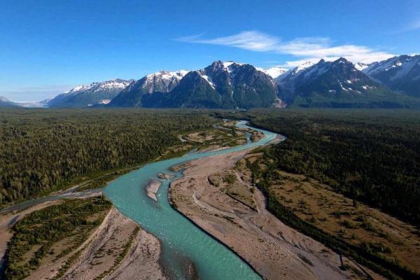
The Tatshenshini river trip is a bucket list trip for many adventurous boaters, if you aren’t up for an adventure then the “Tat” is not for you, it’s tested the mettle of many a seasoned river runner. If you are up for it the Tatshenshini or probably better coined the “Tatshenshini-Alsek” is a river trip that you won’t soon forget.
The Tatshenshini river actually heads up in British Columbia, Canada and flows northwest into the Yukon territories before turning south and west back into British Columbia. The river terminates where it meets the mighty Alsek River, which continues on eventually crossing into Alaska and the United States and flowing until it meets the Pacific Ocean at the mighty “city” of Dry Bay Alaska. Along the way the rivers traverse the Tatshenshini-Alsek Provincial Wilderness Park in Canada and Glacier Bay National Park in Alaska (Together known as the Kluane / Wrangell-St. Elias / Glacier Bay / Tatshenshini-Alsek international park system.
River Changes
In August 2021 a major weather event hit southeast Alaska and while the details of the event are hard to find, the results are a bit easier to see.
From the Alsek River monitoring gauge which is managed by the USGS the results of the event are hard to miss. Here is the river gauge if you would like to look at it: Alsek River Gauge
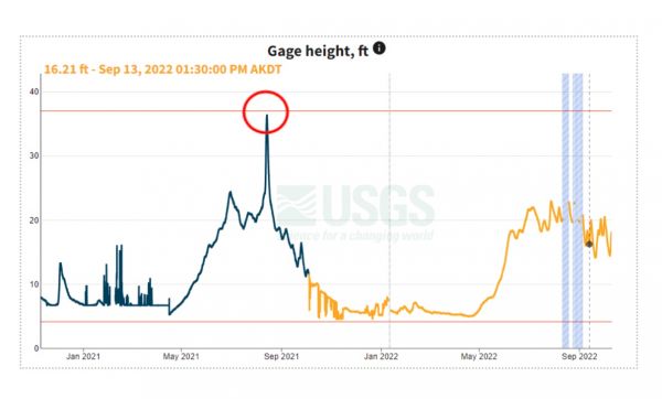

In the time leading up to the August 2021 event the river rose as usual, beginning in May and peaking in July and August (Snowmelt, followed by glacial ice melt). In this case however you can see the huge spike during the period of August 13-15. In this case the gauge height went from around 20 feet to 36 feet, that’s 16’ vertically overnight (see the red circle). In terms of volume the river was running approximately 100,000 ft3/s and then it spiked to over 350,000 ft3/s. For comparison the flow in the Columbia river at Vancouver is around 100,000 ft3/s in the fall, 200,000 in the winter and spring, and around 300,000 in June and July during a normal water year.
While there were undoubtably many changes to both rivers throughout the system we’ll focus on 3 areas in particular:
-
Tatshenshini-Melt Creek Confluence
-
Alsek river (right) just upstream from Alsek Lake
-
Alsek river (left) and glacial lake just upstream from Alsek Lake
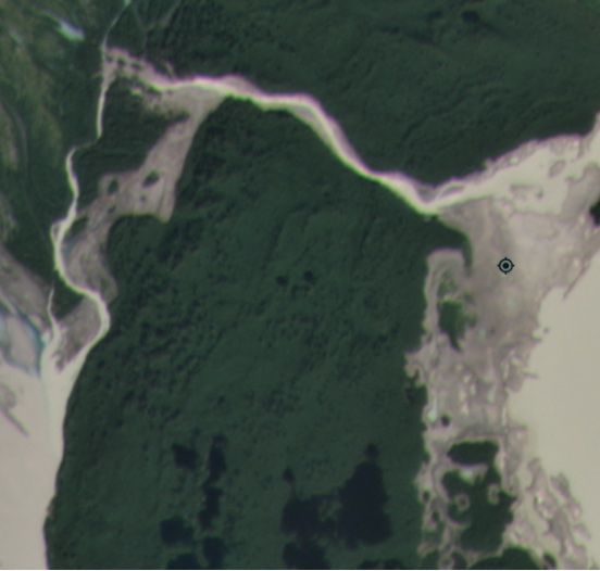
Tatshenshini – Melt Creek Confluence
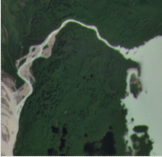
This area is often referred to as the “Center of the universe”. This unique area is truly spectacular and it’s very hard to describe in words. There are towering mountains all around you, each with many perched glaciers as well as some massive glaciers in the distance including the mighty Reynolds glacier in the distance. This is where the Tat meets and disappears into the Alsek river. Before it does however there is a “creek”, it’s a river frankly that enters on river left that is named Melt Creek. Melt Creek is a very short creek that begins just a few miles upstream in a huge glacial lake and its most distinctive feature other than the fact that it’s barely liquid is that it is the most awesome shade of turquoise blue due to the mineralization of the water from the glaciers above.
There are a couple of camps in the area here, one directly above the mouth of the creek and one below the creek above the wash. This is a picture of the confluence from the summer of 2017.
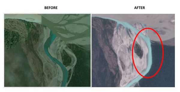
Sometime between August 13 and 14 the event described earlier set up over this area and the resulting rain, melt, and who know what kind of chaos resulted in what you see in the image below.
Melt Creek completely rerouted the lower section of stream course and approximately 20 acres (17 football fields) was washed somewhere downstream, dirt, rocks, trees, and all! The truly scary thing is that the creek now runs within FEET of the upstream camp and if you had been camping there (and I did) when that happened, I suspect thing would have felt pretty “sporty”, especially if you heard the rocks, trees, and stuff from 20 acres beside you evaporating into the river!
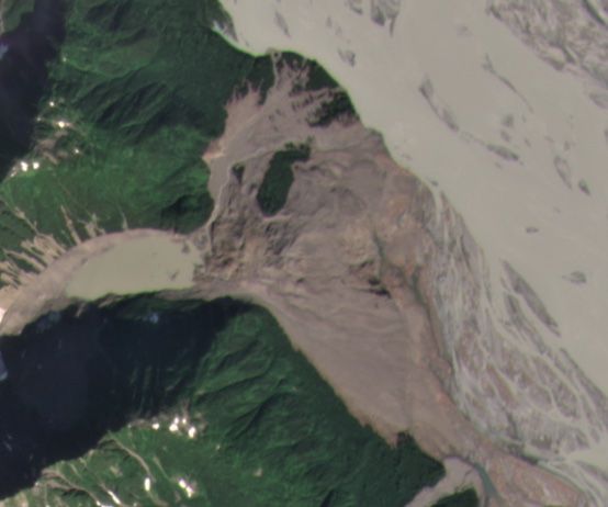
Below is a before and after picture of an area on river right just above Alsek lake. A landslide that originated in the lower left corner of these two images, roughly 50 acres in size slid and completely reshaped the area below, including two glacial lakes and the entire western shoreline of the Alsek river. The area affected was roughly 640 acres, or the size of 1 square section (1 mile square). If you had been camping in this area… well either you would have had stories to tell… or not.
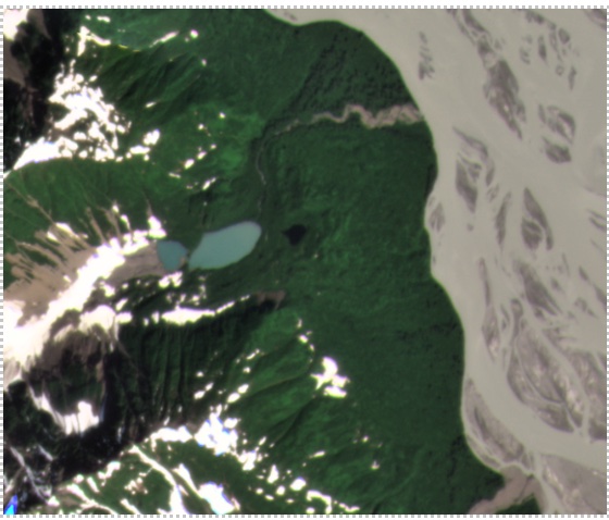
Alsek – Glacial Lake (Left)
Directly across from the area above is a glacial lake that is the terminus of a large glacier. The western edge of the lake can be seen in the picture below. In this case I have to speculate a little but since no one saw this happen no one can prove I’m wrong. Regardless the outlet to this lake blew out with enough force to change the entire course of the lower creek drainage. If you follow the creek on the left you can see it makes a dogleg bend. After the blowout it creek blew though the hill separating it from the next drainage and now the creek is draining out that creek instead. In addition the water in the lake fell several feet exposing the old lakebed due to the outlet of the lake being cut several feet deeper.
All this goes to show just how much changes on river and just how fast those changes can happen. In this case the Tatshenshini-Alsek is a truly wild system and deserves the respect that a truly wild system deserves.