
Trip Report: Not Quite White-Water on the John Day
Farmland Section of the John Day
Submitted by Tom Riggs
Farmland Section May 8-10, 3400 CFS at Monument and falling
Instead of submitting this article to the OWA perhaps I should find the OFA, Oregon Flatwater Association, but since they have high standards for articles you get stuck with this one.
Let’s begin in the Middle. Park your raft at the base of the bridge on river right, North Fork John Day and walk up the two blocks to Boyer’s Cash Market in Monument, Oregon to resupply ice, beer, and spiced rum. You may notice a new RV park being installed at the upstream end of the bridge and the lack of willows make this a decent place to land. Directly under the bridge is even a better spot if the water isn’t above 4500 cfs.
OK, we did launch 4 days earlier on the North Fork John Day near Camas Creek with a layover thrown in for good measure. We passed one group layed over about 10 miles into the trip and other than that, no one. To be fair we launched on a Wednesday but that date was dictated by our permitted downstream entry date into the Service Creek section. May 1st is the beginning of the limited permit entry for John Day river trips downstream of Service Creek.
This farmland section between Monument and Service Creek gets little attention and web searches on this piece substantiate that claim. With topo maps in hand, ONx land ownership app downloaded, locals’ rumors noted, and rafters Paul Morin, and Ann Fullerton piloting the SS Expendable I figured we were set for a new run.
 Floating by the familiar BLM take out at Monument we passed by the river gage and into a short canyon with basalt walls and some minor riffles. Rumors had a diversion dam and old bridge pilings in the river. The topo map showed the concrete dam near river mile 14 as measured from the mouth but only one. Ha! During my previous trip I had seen both manmade obstructions from the road that peeps in and out of view of the river and the second one was at the bridge about 4 miles below the dam and both had nice tongues down the center left and far left channels respectively at 1600 cfs.
We were at 3050 cfs. How would this play out? Let’s see… set down beer, stand up in boat, look left, look right, run tongue on left. Easy Peasey. There are perfect dam reversals that can trap a boat on the right sections of the weir but it appears a portion on the left had been blasted out for boat passage and that was the way to go.
About ¼ mile above the dam on river right was a covered shed with kayaks and SUPs stacked inside so it appears the locals enjoy this section of river as well.
We passed by several fields of alfalfa and hay and could see our next obstacles, the bridge, the abandoned bridge pillars, and again a concrete weir that had a passage blown on the left and at our flow the middle also presented a runnable tongue. This weir had pillars protruding above the water line that may have been bridge supports at one time and may develop some interesting hydraulics at extreme high flows. The left route was our choice and our biggest concern was Paul’s question “is there any rebar ready to eat us?” Being a tough guy I said “no, we eat rebar, it doesn’t eat us.”
Photo: Muscle Tom, submitted by Tom Riggs

Being tough guys (and gal) the hardest part was staying awake on the calm waters of the pastoral float. To liven things up, Paul put Ann on the oars and they soon drifted out of sight. I was alone and God knows how far ahead when the serpent appeared.
 Snake! On the water swimming toward me was a 30” long reptile of dubious character. He must be dubious if he wanted to hang out with me. I figured to change course to ditch him but he followed. As we went around an outside bend I was sure he would opt for the landing in the brush somewhere but nooooo. This dude was after my beer laden boat and he was closing fast. He was elevated in strike position and I was thinking if he submerges he might come up through the drain holes in the self bailing strip. I whipped the boat in circles hoping to confuse his navigation toward my beer. Think like a pirate Tom. Ahhhh… pull my knife and we can go hand to fang combat.
Well, he must have submerged back to the hell hole of his birth ‘cause I didn’t see him again. In the back of my mind I was thinking, be careful unloading the boat, as he may indeed have gained entry from the bottom.
Paul and Ann, like the French Navy, arrived conveniently late to the snake battle and my heroics were duly unnoted.
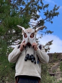
Photo: Mask, submitted by Tom Riggs

Where to Camp? Most of this area is in private hands, but there are two BLM campsites, Big Bend and Lone Tree at river miles 3 and 1. Big Bend has a nice eddy at the top of this car campsite but all four campsites were occupied this Saturday night their tents had the landing sandwiched. Ann guarded the beer as Paul and I walked downstream through the campground and found an unimproved boat ramp at the lower end that would serve as a campsite for us this evening. Up from the boat ramp was a level area that had been used as a camp before, so we deemed this home after our 21 mile day on the river.
 The North Fork merges with the main stem which was smaller in flow by about a third but slightly more greenish opaque. Even though we were passing through Kimberly the overgrown banks screened any buildings from view but we did pass a couple preparing to launch in a canoe for a day trip to Spray, OR, our destination for the night. It was Mother’s Day and there were few cars on the highway that came in and out of view on our float. There is a beautiful home with well manicured landscaping just before the Shady Grove Wayside and it made us wonder what celebrity lives there?
After dodging some barb wire at out lunch stop we headed back downstream and the skies grayed as we caught a corner of a storm that drove us into our rain gear for 15 minutes. The desert smell after the rain helped mask our body musk and we noticed the river banks we littered with thumbnail sized petals which Paul’s phone app identified as coming from the Siberian Elms that were becoming common along the riparian area.
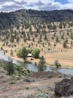
Photo: Wall ck cabin, submitted by Tom Riggs
Spray has a City owned Riverside Park adjacent to a privately owned RV park and it was hard to distinguish the boundary between them save for the line of demarcation boulders. We opted for the Private park since it had grass, some shade trees, and less people driving in and out to see the river or smoke cigarettes. The major reason was it also had an electrical outlet where Paul could recharge his CPAP batteries and avoid being garroted in the middle of the night. Good thing Paul found his 120v power because the store had a sign, “no charging devices. Don’t’ ask”. This market opens at 5:30 and has a backroom where they serve breakfast and lunch as well as a small outdoor seating area.
 We passed by the Spray high school on our return to the boats and proudly displayed on the cyclone fence was a poster of the 2021 graduating class of one. Makes you wonder what he did for the senior prom.
The weather was returning to sunny and warm and we floated through braided channels, passed more farmland and noted potential campsites on BLM land. We ran across a group of 11 on the south shore that was doing a team building day trip from an informal launch site. One girl jumped into the river and gave the obligatory shriek from the cold. Our trip took us under the Wooden Bridge which is also a launch point and we could see river debris well above our heads wrapped on the abutments from the high water of 2019 when the John Day was running 30000 cfs. Head clearance would have been an issue during that event.
Ann’s husband Tom rescued her at Muleshoe Creek and rescued me by bringing two blocks of ice before they departed for the more civilized digs of Three Creeks Brew House in Sisters. Paul and I would raft pass the Service Creek launch point and find a camp at river mile 152.0 before completing the rest of our 10 day trip to Clarno.
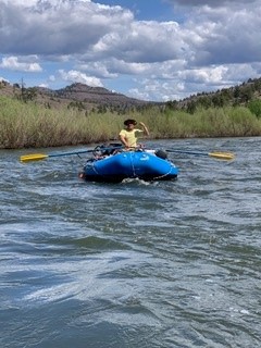
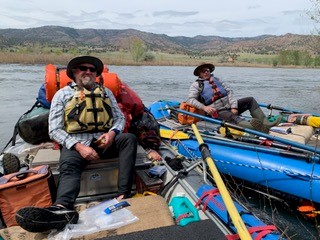
Photo: Morin and Riggs, submitted by Tom Riggs
Potential river camps
-
Big Bend Campground RM 3 North Fork
-
Lone Pine Campground RM 1 North Fork
-
RM 181 right John Day
-
RM 178.5 left John Day
-
RM 171 right Spray Riverside Park or Spray RV Park
-
RM 168 left John Day
-
RM 165 right car camp
-
RM 164.5 car camp
-
RM 162 left below Wooden Bridge
-
RM 159 Muleshoe Campground